GEM Hazard Model Documentation
v2026.1 update coming soon!
The GEM Global Seismic Hazard Map, v. 2023.1
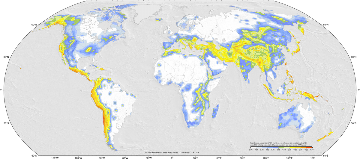
This map shows PGA with a 10% probability of being in exceeded in 50 years on reference site conditions (Vs30=760-800m/s). Download the map HERE or download version 2018.1 HERE!.
Welcome to the documentation for the GEM Global Seismic Hazard Mosaic! The
mosaic is a collection of 30 national and regional seismic hazard models
covering the entire globe. It consists of hazard models developed by various
institutions, within collaborative projects, and by the GEM Foundation – all
described in a consistent format compatible with the OpenQuake Engine.
Here you can find a description of every model in the Mosaic. For information on model use,
see the GEM Products Page
References
Pagani, M., Garcia-Pelaez, J., Gee, R., Johnson, K., Poggi, V., Styron, R., Weatherill, G., Simionato, M., Viganò, D., Danciu, L., Monelli , D. (2018). Global Earthquake Model (GEM) Seismic Hazard Map (version 2018.1 - December 2018), doi.org/10.13117/GEM-GLOBAL-SEISMIC-HAZARD-MAP-2018.1
Pagani, M, Garcia-Pelaez, J, Gee, R, Johnson, K, Silva, V, Simionato, M, Styron, R, Vigano, D, Danciu, L, Monelli, D, Poggi, V, Weatherill, G (2020). The 2018 version of the Global Earthquake Model: Hazard component. Earthquake Spectra. DOI: 10.1177/8755293020931866